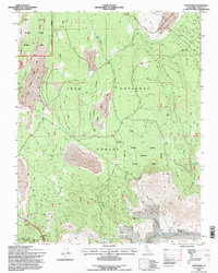
1994 Map of Crestview
USGS Topo · Published 1997About this map
Mono Craters dominate the western landscape of this 1994 survey, where volcanic geology meets the high-altitude forests of Mono County. The map details a transition from the volcanic ridges of the Mono National Forest Scenic Area to the expansive flats of Long Valley in the southeast. A network of four-wheel-drive trails and forest roads connects the small settlement at Crestview with geological landmarks like Bald Mountain and Indiana Summit. The hydrology of the area is defined by the headwaters of the Owens River, which draws from Big Springs and Deadman Creek. The inclusion of the Indiana Summit Research Natural Area highlights the scientific value of this terrain, while smaller markers like the Radio Tower and Tailings near the volcanic craters hint at modern communication and past mineral exploration in the Inyo National Forest.
Find a feature on this map
26 named features on this map. Tap any name to fly to it.
Don’t see what you’re looking for? This feature index may not catch every label — zoom into the map to look around manually.
Map Details
Editions of this 1994 Crestview Map
This is the sole edition of this map. No revisions or reprints were ever made.
Other maps of this area

1901 · Mt. Lyell
USGS Topo · 1:125,000

1914 · Mt. Morrison
USGS Topo · 1:125,000

1947 · Mariposa
USGS Topo · 1:250,000

1948 · Mariposa
USGS Topo · 1:250,000

1953 · Mt. Morrison
USGS Topo · 1:62,500

1953 · Mono Craters
USGS Topo · 1:62,500

1953 · Devils Postpile
USGS Topo · 1:62,500

1957 · Mariposa
USGS Topo · 1:250,000

1962 · Cowtrack Mtn
USGS Topo · 1:62,500

1963 · Mariposa
USGS Topo · 1:250,000