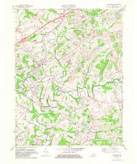
1981 Map of Crestwood
USGS Topo · Published 1982About this map
Pewee Valley and Crestwood serve as the primary hubs in this region during the early 1980s, shaped by the path of the Louisville and Nashville railroad. The landscape is defined by the winding course of Floyds Fork and its numerous tributaries, including Ashers Run and Long Run. The map provides significant genealogical value through its many burial grounds, notably the Confederate Cem and Pewee Valley Cem, alongside rural landmarks like the State Correctional Institute for Women. Small communities such as Floydsburg and Centerfield sit among a terrain dotted with local institutions like St James Ch and St Aloysius Sch. The area reflects a late 20th-century mix of growing suburban settlements and established agricultural lands, with features like Mt Tabor rising above the creek valleys.
Find a feature on this map
47 named features on this map. Tap any name to fly to it.
Don’t see what you’re looking for? This feature index may not catch every label — zoom into the map to look around manually.
Map Details
Editions of this 1981 Crestwood Map
2 editions found
Other maps of this area

1905 · Prospect
USGS Topo · 1:62,500

1907 · Louisville
USGS Topo · 1:62,500

1912 · Prospect
USGS Topo · 1:62,500

1929 · Taylorsville
USGS Topo · 1:62,500

1932 · La Grange
USGS Topo · 1:62,500

1938 · Owen
USGS Topo · 1:24,000

1948 · Owen
USGS Topo · 1:24,000

1951 · Anchorage
USGS Topo · 1:24,000

1951 · Crestwood
USGS Topo · 1:24,000

1951 · Jeffersontown
USGS Topo · 1:24,000