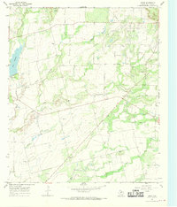
1967 Map of Crews
USGS Topo · Published 1970About this map
Lake Winters anchors the northwestern corner of this Runnels County landscape, where the waters of Elm Creek are impounded before flowing south. The map reflects a mid-century rural economy defined by petroleum extraction and ranching, prominently featuring the Sykes Oil Field and Clayton Oil Field. Evidence of industrial infrastructure is scattered throughout the terrain, from a Gas Plant and Radio Tower to several Gravel Pits and a dedicated Landing Strip.
Find a feature on this map
19 named features on this map. Tap any name to fly to it.
Don’t see what you’re looking for? This feature index may not catch every label — zoom into the map to look around manually.
Map Details
Editions of this 1967 Crews Map
2 editions found
Other maps of this area

1890 · Abilene
USGS Topo · 1:125,000

1892 · Abilene
USGS Topo · 1:125,000

1892 · Ballinger
USGS Topo · 1:125,000

1921 · Hatchel
USGS Topo · 1:31,680

1954 · Brownwood
USGS Topo · 1:250,000

1954 · Abilene
USGS Topo · 1:250,000

1958 · Abilene
USGS Topo · 1:250,000
1967 · Hatchel
USGS Topo · 1:24,000

1967 · Talpa
USGS Topo · 1:24,000

1967 · Novice West
USGS Topo · 1:24,000