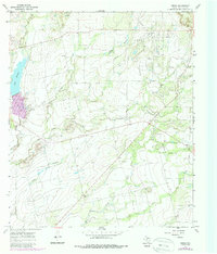
1967 Map of Crews
USGS Topo · Published 1988About this map
The rolling plains of northeastern Runnels County are defined by a mix of ranching and petroleum extraction in this late 1960s survey. The landscape is marked by the Sykes Oil Field and Clayton Oil Field, where industrial infrastructure like a Gas Plant and a Landing Strip sit alongside established rural communities. Small settlements such as Crews and Davenport serve as local anchors, while the Harmony Ch and Hopewell Ch provide evidence of the area's long-standing social and religious foundations. Water is a central element of the terrain, with Lake Winters in the west and a network of drainages including Elm Creek and Mud Creek carving through the land. This map captures the region just as photogrammetric revisions were beginning to document subtle shifts in land use and fencing across the Texas brush country.
Find a feature on this map
19 named features on this map. Tap any name to fly to it.
Don’t see what you’re looking for? This feature index may not catch every label — zoom into the map to look around manually.
Map Details
Editions of this 1967 Crews Map
2 editions found
Other maps of this area

1890 · Abilene
USGS Topo · 1:125,000

1892 · Abilene
USGS Topo · 1:125,000

1892 · Ballinger
USGS Topo · 1:125,000

1921 · Hatchel
USGS Topo · 1:31,680

1954 · Brownwood
USGS Topo · 1:250,000

1954 · Abilene
USGS Topo · 1:250,000

1958 · Abilene
USGS Topo · 1:250,000
1967 · Hatchel
USGS Topo · 1:24,000

1967 · Talpa
USGS Topo · 1:24,000

1967 · Novice West
USGS Topo · 1:24,000