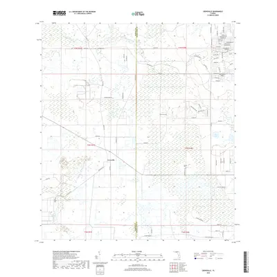
2018 Map of Crewsville
USGS Topo · Published 2018About this map
Crewsville stands as the primary namesake settlement of this interior Florida landscape, situated along the county boundary between Hardee and Highlands. The terrain is characterized by the prominent Lake Wales Ridge, which influences the local drainage patterns and creates a distinct sandy upland environment amidst the surrounding wetlands. This 2018 survey reveals a rural network defined by large land parcels and scattered homesteads, punctuated by family and community landmarks such as Whitten and Prescott Cem. To the northwest, Little Charley Bowlegs Cr meanders through the landscape, while Oak Creek Cem provides a point of genealogical interest in the western portion of the quadrangle. The eastern edge transition into a more developed grid of residential roads with bird-themed names like Nightingale Ave and Starling Ave, reflecting a later phase of subdivision and land use change.
Find a feature on this map
72 named features on this map. Tap any name to fly to it.
Don’t see what you’re looking for? This feature index may not catch every label — zoom into the map to look around manually.
Map Details
Editions of this 2018 Crewsville Map
This is the sole edition of this map. No revisions or reprints were ever made.
Other maps of this area

1952 · Lake Arbuckle SW
USGS Topo · 1:24,000

1952 · Sebring
USGS Topo · 1:24,000

1953 · Avon Park
USGS Topo · 1:24,000

1953 · Lake June In Winter
USGS Topo · 1:24,000

1953 · Crewsville SE
USGS Topo · 1:24,000

1953 · Crewsville
USGS Topo · 1:24,000

1956 · Sweetwater
USGS Topo · 1:24,000

1956 · Crewsville SW
USGS Topo · 1:24,000

1956 · Griffins Corner
USGS Topo · 1:24,000

1956 · Fort Pierce
USGS Topo · 1:250,000