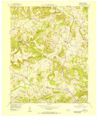
1954 Map of Crider
USGS Topo · Published 1955About this map
The hill country of Caldwell County during the mid-1950s is defined by a dense network of upland ridges and the industrial extraction of its mineral resources. The Illinois Central railroad cuts through the southern portion of the quadrangle, serving the small community of Crider. Nearby, active extraction is visible at the Williamson Mines, while other sites like the Black Sulphur Mines and Powder Mines indicate a landscape heavily shaped by mining activity.
Find a feature on this map
98 named features on this map. Tap any name to fly to it.
Don’t see what you’re looking for? This feature index may not catch every label — zoom into the map to look around manually.
Map Details
Editions of this 1954 Crider Map
This is the sole edition of this map. No revisions or reprints were ever made.
Other maps of this area

1908 · Princeton
USGS Topo · 1:62,500

1909 · Providence
USGS Topo · 1:62,500

1910 · Princeton
USGS Topo · 1:62,500

1916 · Fords Ferry
USGS Topo · 1:62,500

1921 · Fords Ferry
USGS Topo · 1:48,000

1925 · Cave In Rock
USGS Topo · 1:62,500

1928 · Eddyville
USGS Topo · 1:48,000

1931 · Eddyville
USGS Topo · 1:62,500

1936 · Eddyville
USGS Topo · 1:48,000

1949 · Paducah
USGS Topo · 1:250,000