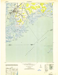
1953 Map of Crisfield
USGS Topo · Published 1953About this map
The maritime identity of Crisfield is etched into every shoreline and channel of this 1953 survey, where the town serves as a vital hub for the Maryland seafood industry. Situated between the Annemessex River and Pocomoke Sound, the landscape is a complex network of marshlands and tidal guts like Landing Gut and Cedar Gut. The town's infrastructure reflects its role as a regional center, featuring the Pennsylvania railroad line terminating at the waterfront, the Armory, and McCready Mem Hospital.
Find a feature on this map
82 named features on this map. Tap any name to fly to it.
Don’t see what you’re looking for? This feature index may not catch every label — zoom into the map to look around manually.
Map Details
Editions of this 1953 Crisfield Map
3 editions found
Other maps of this area

1903 · Crisfield
USGS Topo · 1:62,500

1903 · Deal Island
USGS Topo · 1:62,500

1920 · Crisfield
USGS Topo · 1:62,500

1942 · Chesconessex
USGS Topo · 1:31,680

1942 · Terrapin Sand Point
USGS Topo · 1:24,000

1942 · Great Fox Island
USGS Topo · 1:24,000

1942 · Marion
USGS Topo · 1:24,000

1942 · Kingston
USGS Topo · 1:24,000

1942 · Tangier Island
USGS Topo · 1:24,000

1942 · Saxis
USGS Topo · 1:24,000