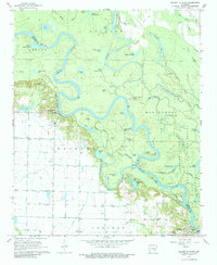
1967 Map of Crocketts Bluff
USGS Topo · Published 1984About this map
Crocketts Bluff and St Charles anchor this riverine landscape, where the meandering White River defines the boundary between Arkansas and Monroe counties. This 1967 survey reveals a complex network of oxbows and backwaters, including Maddox Bay, Goose Lake, and Tupelo Lake, indicating a terrain heavily influenced by the shifting river channel. The eastern portion of the sheet is largely preserved within the White River National Wildlife Refuge, a dense environment of sloughs and brakes like Dawson Slough and Ash Slash. Local heritage is preserved in the location of the Lutheran Cem and rural centers such as the Hopewell Ch and Hopewell Sch. The presence of Bark Shanty Lake and Browns Shanty Lake hints at a history of seasonal camps or early riverfront settlements along the lower reaches of the White River valley.
Find a feature on this map
63 named features on this map. Tap any name to fly to it.
Don’t see what you’re looking for? This feature index may not catch every label — zoom into the map to look around manually.
Map Details
Editions of this 1967 Crocketts Bluff Map
3 editions found
Other maps of this area

1935 · Clarendon
USGS Topo · 1:62,500

1939 · Indian Bay
USGS Topo · 1:62,500

1940 · Holly Grove
USGS Topo · 1:62,500

1941 · De Witt
USGS Topo · 1:62,500

1941 · Clarendon
USGS Topo · 1:62,500

1948 · Helena
USGS Topo · 1:250,000

1950 · Helena
USGS Topo · 1:250,000

1954 · Indian Bay
USGS Topo · 1:62,500

1954 · De Witt
USGS Topo · 1:62,500

1955 · Helena
USGS Topo · 1:250,000