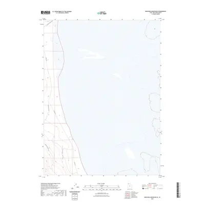
2023 Map of Crocodile Mountain SE
USGS Topo · Published 2023About this map
The Hogup Mountains define the western portion of this terrain, where the high desert landscape meets the expansive flats to the east. This modern survey illustrates the sparse network of access routes that navigate the transition from elevation to level basin. Specifically, the corridor established by E Hogup Rd and Upper East Hogup Rd provides a look at how contemporary land management and transit are organized around these prominent geographical features. While much of the quadrangle is dominated by open salt flats or basins, the concentration of topography and named roads in the west reflects the primary areas of human activity and navigation in this corner of Box Elder County.
Find a feature on this map
4 named features on this map. Tap any name to fly to it.
Don’t see what you’re looking for? This feature index may not catch every label — zoom into the map to look around manually.
Map Details
Editions of this 2023 Crocodile Mountain SE Map
This is the sole edition of this map. No revisions or reprints were ever made.
Other maps of this area

1954 · Brigham City
USGS Topo · 1:250,000

1958 · Brigham City
USGS Topo · 1:250,000

1962 · Brigham City
USGS Topo · 1:250,000

1969 · Peplin Flats
USGS Topo · 1:24,000

1969 · Spring Bay SW
USGS Topo · 1:24,000

1969 · Dolphin Island West
USGS Topo · 1:24,000

1969 · Locomotive Springs
USGS Topo · 1:24,000
1969 · Dolphin Island East
USGS Topo · 1:24,000

1969 · Crocodile Mtn NE
USGS Topo · 1:24,000

1969 · Hogup Bar
USGS Topo · 1:24,000