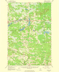
1961 Map of Cromwell
USGS Topo · Published 1975About this map
Cromwell and the surrounding townships of Kalevala and Automba are defined by a complex network of glacial lakes and wetlands during the early 1960s. The region's transport and industrial identity is shaped by the Burlington Northern and Northern Pacific railroads, which parallel the transition from agricultural clearings to the dense timber of the Fond Du Lac State Forest. Local genealogy and community life are anchored in sites like Immaculate Conception Ch and the Kalevala Sch, while the presence of numerous Gravel Pits points to the area's extractive economy.
Find a feature on this map
57 named features on this map. Tap any name to fly to it.
Don’t see what you’re looking for? This feature index may not catch every label — zoom into the map to look around manually.
Map Details
Editions of this 1961 Cromwell Map
2 editions found
Other maps of this area

1953 · Duluth
USGS Topo · 1:250,000

1954 · Sawyer
USGS Topo · 1:24,000

1954 · Martin Lake
USGS Topo · 1:24,000

1956 · Barnum
USGS Topo · 1:62,500

1958 · Duluth
USGS Topo · 1:250,000

1961 · Cromwell
USGS Topo · 1:62,500

1961 · Moose Lake
USGS Topo · 1:62,500

1962 · Bruno
USGS Topo · 1:62,500

1963 · Gowan
USGS Topo · 1:24,000

1963 · Prairie Lake
USGS Topo · 1:24,000