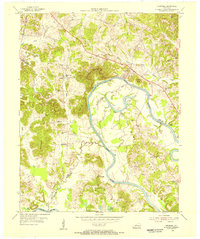
1954 Map of Cromwell
USGS Topo · Published 1955About this map
The Green River carves a massive, winding path through the borderlands of Ohio and Butler counties, defining the economic and social life of this mid-century Kentucky landscape. In the Big Bend south of Logansport, the river’s influence is clear through the presence of Reeds Ferry and numerous sloughs and lakes like Hurricane Slough and Taylor Lake. The terrain is marked by high-elevation landmarks such as Tilford Knob and Keel Hill, while the western edge of the quadrangle shows the early impact of industry with several active Strip Mine sites near the Illinois Central railroad line. Settlement is dispersed across small communities like Cromwell and Shultztown, each anchored by local institutions such as the Shultztown Cem and Salem Ch. The map captures a transitional moment where traditional river crossings and family cemeteries like Paxton Cem and Shields Cem exist alongside modern infrastructure like U.S. 231.
Find a feature on this map
40 named features on this map. Tap any name to fly to it.
Don’t see what you’re looking for? This feature index may not catch every label — zoom into the map to look around manually.
Map Details
Editions of this 1954 Cromwell Map
2 editions found
Other maps of this area

1909 · Hartford
USGS Topo · 1:62,500

1911 · Dunmor
USGS Topo · 1:48,000

1914 · Little Muddy
USGS Topo · 1:62,500

1914 · Dunmor
USGS Topo · 1:62,500

1925 · Spring Lick
USGS Topo · 1:62,500

1953 · South Hill
USGS Topo · 1:24,000

1953 · Rochester
USGS Topo · 1:24,000

1954 · Evansville
USGS Topo · 1:250,000

1954 · Horton
USGS Topo · 1:24,000
1954 · Paradise
USGS Topo · 1:24,000