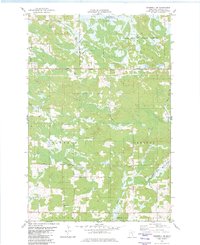
1982 Map of Cromwell SE
USGS Topo · Published 1982About this map
The northern reaches of the Fond Du Lac State Forest and the Kettle Lake State Wildlife Managment Area define the wooded landscape of this Carlton County region during the late 1970s. The terrain is a network of water and wetlands, where the Kettle River flows southward through the western half while the West Fork Moose River and Moose Horn River drain the eastern sections. Local life is concentrated along a grid of rural routes including Mahtowa Road, Granlund Road, and Moline Road.
Find a feature on this map
20 named features on this map. Tap any name to fly to it.
Don’t see what you’re looking for? This feature index may not catch every label — zoom into the map to look around manually.
Map Details
Editions of this 1982 Cromwell SE Map
This is the sole edition of this map. No revisions or reprints were ever made.
Other maps of this area

1953 · Duluth
USGS Topo · 1:250,000

1954 · Sawyer
USGS Topo · 1:24,000

1956 · Barnum
USGS Topo · 1:62,500

1958 · Duluth
USGS Topo · 1:250,000

1961 · Cromwell
USGS Topo · 1:62,500

1961 · Moose Lake
USGS Topo · 1:62,500

1962 · Bruno
USGS Topo · 1:62,500

1980 · Sandstone
USGS Topo · 1:100,000

1980 · Duluth
USGS Topo · 1:100,000

1981 · Kettle River
USGS Topo · 1:24,000