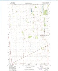
1982 Map of Crookston NE
USGS Topo · Published 1982About this map
Townhall and the small community of Belgium anchor this portion of Polk County, where the landscape is defined by the rigid geometry of township borders and agricultural drainage. Managed conservation lands such as the Belgium State Wildlife Management Area and Pembina State Wildlife Management Area provide breaks in the grid, preserving wetlands and prairie habitat amidst the heavy industrial agriculture of the Red River Valley. The Burlington Northern railroad corridor cuts a diagonal through the southwest, while an extensive network of man-made waterways, including Judicial Ditch No 147 and Judicial Ditch No 60, reveals the massive engineering effort required to drain this fertile flatland for farming. Local landmarks like the Radio Tower and numerous Gravel Pits serve as modern navigational markers in this expansive landscape.
Find a feature on this map
14 named features on this map. Tap any name to fly to it.
Don’t see what you’re looking for? This feature index may not catch every label — zoom into the map to look around manually.
Map Details
Editions of this 1982 Crookston NE Map
This is the sole edition of this map. No revisions or reprints were ever made.
Other maps of this area

1918 · Angus
USGS Topo · 1:62,500

1918 · Red Lake Falls
USGS Topo · 1:62,500

1918 · Viking
USGS Topo · 1:62,500

1952 · Red Lake Falls
USGS Topo · 1:62,500

1952 · Grand Forks
USGS Topo · 1:250,000

1952 · Thief River Falls
USGS Topo · 1:250,000

1953 · Crookston
USGS Topo · 1:62,500

1956 · Thief River Falls
USGS Topo · 1:250,000

1956 · Grand Forks
USGS Topo · 1:250,000

1957 · Thief River Falls
USGS Topo · 1:250,000