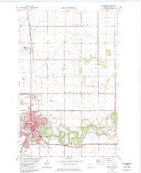
1982 Map of Crookston
USGS Topo · Published 1982About this map
Crookston serves as a regional hub in Polk County, defined by the winding course of the Red Lake River and its position within the fertile Red River Valley. In the early 1980s, the community was a nexus of agriculture and transportation, anchored by the Burlington Northern railroad lines that converged here to move grain and goods through the prairie landscape. The map details the transition from the concentrated urban grid of the city to the expansive surrounding townships, including the northern settlement of Shirley and the industrial activity near Carman. To the northwest, the flat terrain of Fanny reflects the agricultural legacy of the region, where large sections of land are organized around systematic drainage and rail access. The survey captures the town's mature layout, showing the integration of local parks, schools, and institutional grounds against the meandering river loops that have historically shaped the city's growth.
Find a feature on this map
5 named features on this map. Tap any name to fly to it.
Don’t see what you’re looking for? This feature index may not catch every label — zoom into the map to look around manually.
Map Details
Editions of this 1982 Crookston Map
This is the sole edition of this map. No revisions or reprints were ever made.
Other maps of this area

1918 · Red Lake Falls
USGS Topo · 1:62,500

1919 · Beltrami
USGS Topo · 1:62,500

1952 · Red Lake Falls
USGS Topo · 1:62,500

1952 · Grand Forks
USGS Topo · 1:250,000

1953 · Crookston
USGS Topo · 1:62,500

1956 · Grand Forks
USGS Topo · 1:250,000

1964 · Girard
USGS Topo · 1:24,000

1964 · Greenview
USGS Topo · 1:24,000

1965 · Harold
USGS Topo · 1:24,000

1966 · Grand Forks
USGS Topo · 1:250,000