
1964 Map of Girard
USGS Topo · Published 1965About this map
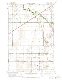
The Great Northern railroad cuts a diagonal line across this landscape, passing through the small settlement of Girard and near Wilds. This 1964 survey captures a region defined by an extensive engineering effort to manage the water of the Red River Valley, evidenced by a dense grid of drainage systems including County Ditch No 112, County Ditch No 69, and County Ditch No 94. These canals parallel the section lines of Andover and Rome townships, supporting the agricultural development of the flat, low-lying terrain. Genealogy researchers can find precisely located burial grounds like Andover Cem and Hanna Cem, while the natural meandering path of Burnham Creek provides a sharp contrast to the straight-line human interventions of the ditches and rail corridor.
Find a feature on this map
27 named features on this map. Tap any name to fly to it.
Don’t see what you’re looking for? This feature index may not catch every label — zoom into the map to look around manually.
Map Details
Editions of this 1964 Girard Map
2 editions found
Other maps of this area

1919 · Eldred
USGS Topo · 1:62,500

1919 · Beltrami
USGS Topo · 1:62,500

1952 · Grand Forks
USGS Topo · 1:250,000

1953 · Crookston
USGS Topo · 1:62,500

1956 · Grand Forks
USGS Topo · 1:250,000

1964 · Beltrami
USGS Topo · 1:24,000

1964 · Beltrami SW
USGS Topo · 1:24,000

1964 · Greenview
USGS Topo · 1:24,000
1964 · Climax
USGS Topo · 1:24,000
1964 · Fisher
USGS Topo · 1:24,000