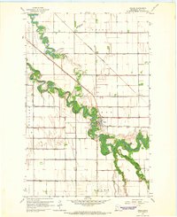
1964 Map of Fisher
USGS Topo · Published 1966About this map
The Fisher settlement serves as the focal point of this mid-1960s survey, situated along a dramatic bend in the Red Lake River. The landscape is defined by the heavy modification of the Red River Valley’s flat terrain, evidenced by an extensive network of drainage infrastructure such as County Ditch No 30 and County Ditch No 134. This engineering was essential for the agricultural development of townships like Huntsville, Nesbit, and Bygland.
Find a feature on this map
27 named features on this map. Tap any name to fly to it.
Don’t see what you’re looking for? This feature index may not catch every label — zoom into the map to look around manually.
Map Details
Editions of this 1964 Fisher Map
This is the sole edition of this map. No revisions or reprints were ever made.
Other maps of this area

1919 · Eldred
USGS Topo · 1:62,500

1919 · Beltrami
USGS Topo · 1:62,500

1952 · Grand Forks
USGS Topo · 1:250,000

1953 · Crookston
USGS Topo · 1:62,500

1956 · Grand Forks
USGS Topo · 1:250,000
1963 · Mallory
USGS Topo · 1:24,000
1963 · Key West
USGS Topo · 1:24,000

1964 · Girard
USGS Topo · 1:24,000

1964 · Climax NW
USGS Topo · 1:24,000
1964 · Bygland
USGS Topo · 1:24,000