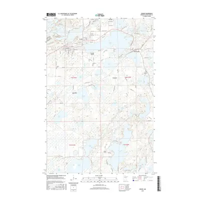
2016 Map of Crosby
USGS Topo · Published 2016About this map
Serpent Lake and the surrounding cluster of mining-era settlements define this portion of the Cuyuna Iron Range. The close proximity of Crosby, Ironton, and Cuyuna reflects the intensive industrial development of the early 20th century, where worker housing and commercial districts grew up alongside active mine pits and processing facilities like the Crusher near Menomin Lake. The landscape is heavily altered by these extraction efforts, visible in the numerous lakes that now fill former mine sites and the complex road network, including names like Switchback and Silkstone Dr. To the south, the terrain transitions into a dense network of natural water bodies, including Clearwater Lake and the Nokasippi River. Local history and genealogy are anchored by established sites such as Irondale Cem, Lakewood Cem, and Deerwood Cem, which serve as permanent markers for the families who settled this lake-studded region.
Find a feature on this map
108 named features on this map. Tap any name to fly to it.
Don’t see what you’re looking for? This feature index may not catch every label — zoom into the map to look around manually.
Map Details
Editions of this 2016 Crosby Map
This is the sole edition of this map. No revisions or reprints were ever made.
Other maps of this area

1912 · Deerwood
USGS Topo · 1:62,500

1913 · Cuyuna
USGS Topo · 1:62,500

1914 · Deerwood
USGS Topo · 1:62,500

1915 · Cuyuna
USGS Topo · 1:62,500

1915 · Brainerd
USGS Topo · 1:62,500

1918 · Brainerd
USGS Topo · 1:62,500

1953 · Duluth
USGS Topo · 1:250,000

1953 · Brainerd
USGS Topo · 1:250,000

1957 · Brainerd
USGS Topo · 1:250,000

1958 · Brainerd
USGS Topo · 1:250,000