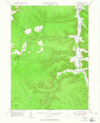
1948 Map of Crosby
USGS Topo · Published 1965About this map
Potato Creek carves a deep valley through the northern Allegheny Plateau, anchoring a landscape defined by timber-era settlements and early industrial infrastructure. In this mid-century environment, the village of Crosby and nearby Colegrove sit along the narrow valley floor, connected by the Pennsylvania railroad line that follows the river's path. To the west, the high terrain of Sergeant township is marked by the remote settlement of Clermont, where the Clermont Cem and local school buildings once served a community centered on natural resource extraction. The map reveals an intricate network of Pipe Lines threading through steep hollows like Wernwag Hollow and Spangler Hol, tracing the region's history of oil and gas transit. From the southern boundary at the McKean Co Elk Co line to the industrial sidings at Hamlin Sta, this survey captures the transition between mountain wilderness and the rail-dependent economies of the late 1940s.
Find a feature on this map
49 named features on this map. Tap any name to fly to it.
Don’t see what you’re looking for? This feature index may not catch every label — zoom into the map to look around manually.
Map Details
Editions of this 1948 Crosby Map
Other maps of this area

1924 · Bradford
USGS Topo · 1:62,500

1926 · Bradford
USGS Topo · 1:62,500

1933 · Smethport
USGS Topo · 1:62,500

1935 · Mt. Jewett
USGS Topo · 1:48,000

1937 · Smethport
USGS Topo · 1:62,500

1940 · Mt. Jewett
USGS Topo · 1:62,500

1941 · Bradford
USGS Topo · 1:62,500

1944 · Bradford
USGS Topo · 1:62,500

1948 · Crosby
USGS Topo · 1:62,500

1948 · Wildwood Fire Tower
USGS Topo · 1:24,000
Featured Places
- Norwich Township, PA
- Crosby, Norwich Township
- Colegrove, Norwich Township
- Betula, Norwich Township
- Jones Township, PA