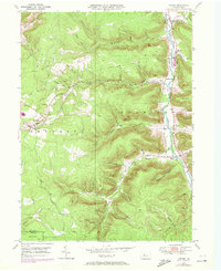
1948 Map of Crosby
USGS Topo · Published 1972About this map
Potato Creek serves as the central drainage for this landscape, winding through a valley that supported several small hamlets and industrial transit points during the mid-twentieth century. The Pennsylvania railroad line parallels the creek, connecting settlements like Crosby, Colegrove, and Hamlin Sta. To the west, the village of Clermont sits on higher ground, surrounded by a complex network of narrow hollows including Shelander Hol and Spangler Hol.
Find a feature on this map
53 named features on this map. Tap any name to fly to it.
Don’t see what you’re looking for? This feature index may not catch every label — zoom into the map to look around manually.
Map Details
Editions of this 1948 Crosby Map
Other maps of this area

1924 · Bradford
USGS Topo · 1:62,500

1926 · Bradford
USGS Topo · 1:62,500

1933 · Smethport
USGS Topo · 1:62,500

1935 · Mt. Jewett
USGS Topo · 1:48,000

1937 · Smethport
USGS Topo · 1:62,500

1940 · Mt. Jewett
USGS Topo · 1:62,500

1941 · Bradford
USGS Topo · 1:62,500

1944 · Bradford
USGS Topo · 1:62,500

1948 · Crosby
USGS Topo · 1:62,500

1948 · Wildwood Fire Tower
USGS Topo · 1:24,000
Featured Places
- Norwich Township, PA
- Crosby, Norwich Township
- Colegrove, Norwich Township
- Betula, Norwich Township
- Jones Township, PA