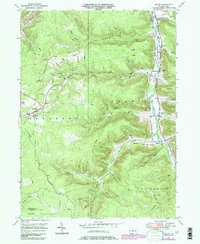
1948 Map of Crosby
USGS Topo · Published 1986About this map
Potato Creek flows through the heart of this McKean County landscape, carving a valley where the settlements of Crosby and Colegrove took root. The geography is defined by a dense network of hollows and runs, such as Browns Mill Hol and Wentwag Hollow, which speak to the early family names and localized industry of the Norwich and Sergeant townships. An Old Railroad Grade traces the terrain near Hamlin Sta, marking the legacy of the timber or coal transport that once dominated these hills.
Find a feature on this map
51 named features on this map. Tap any name to fly to it.
Don’t see what you’re looking for? This feature index may not catch every label — zoom into the map to look around manually.
Map Details
Editions of this 1948 Crosby Map
Other maps of this area

1924 · Bradford
USGS Topo · 1:62,500

1926 · Bradford
USGS Topo · 1:62,500

1933 · Smethport
USGS Topo · 1:62,500

1935 · Mt. Jewett
USGS Topo · 1:48,000

1937 · Smethport
USGS Topo · 1:62,500

1940 · Mt. Jewett
USGS Topo · 1:62,500

1941 · Bradford
USGS Topo · 1:62,500

1944 · Bradford
USGS Topo · 1:62,500

1948 · Crosby
USGS Topo · 1:62,500

1948 · Wildwood Fire Tower
USGS Topo · 1:24,000
Featured Places
- Norwich Township, PA
- Crosby, Norwich Township
- Colegrove, Norwich Township
- Betula, Norwich Township
- Jones Township, PA