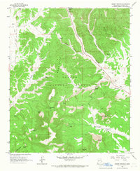
1964 Map of Crosby Springs
USGS Topo · Published 1967About this map
Cibola National Forest defines the topography of this mid-1960s survey, where the rugged terrain of the Datil Mountains is carved by deep drainages like White House Canyon and Crosby Canyon. This is a landscape characterized by isolated water sources and high-altitude ranching infrastructure. Numerous named wells and springs, such as Jonnies Well and White House Spring, serve as vital landmarks across the canyons. The presence of the Baldwin Cabin and the Sawmill Well near the base of Anderson Mountain suggests a history of remote settlement and timber or livestock activity. Notable peaks like East Sugarloaf Mountain rise above the drainage systems of Slash Draw and Flying V Draw, while the inclusion of the Gravel Pit indicates localized industrial extraction within the forest boundaries during this era.
Find a feature on this map
40 named features on this map. Tap any name to fly to it.
Don’t see what you’re looking for? This feature index may not catch every label — zoom into the map to look around manually.
Map Details
Editions of this 1964 Crosby Springs Map
2 editions found

Other maps of this area

1954 · Saint Johns
USGS Topo · 1:250,000

1954 · Socorro
USGS Topo · 1:250,000

1957 · Saint Johns
USGS Topo · 1:250,000

1958 · Socorro
USGS Topo · 1:250,000

1958 · Saint Johns
USGS Topo · 1:250,000

1962 · Socorro
USGS Topo · 1:250,000

1962 · Saint Johns
USGS Topo · 1:250,000

1963 · Cal Ship Mesa
USGS Topo · 1:24,000

1963 · Anderson Peak
USGS Topo · 1:24,000

1963 · Datil
USGS Topo · 1:24,000