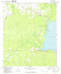
1979 Map of Cross
USGS Topo · Published 1980About this map
The community of Cross and its surrounding Lowcountry landscape are defined by the eastern shoreline of Lake Moultrie and the engineered West Seawall Dike. This late 1970s survey captures the intersection of rural Berkeley County life and large-scale water management projects, such as the Diversion Canal in the northeast. The interior is characterized by a series of oval-shaped Carolina Bays, including Skeleton Bay, Beech Island Bay, and Pigeon Bay, which punctuate the wetlands and forest.
Find a feature on this map
38 named features on this map. Tap any name to fly to it.
Don’t see what you’re looking for? This feature index may not catch every label — zoom into the map to look around manually.
Map Details
Editions of this 1979 Cross Map
2 editions found
Other maps of this area

1919 · Summerville
USGS Topo · 1:48,000

1919 · Ridgeville
USGS Topo · 1:48,000

1920 · Eutawville
USGS Topo · 1:48,000

1920 · Chicora
USGS Topo · 1:48,000

1920 · Ridgeville
USGS Topo · 1:62,500

1920 · Summerville
USGS Topo · 1:62,500

1921 · Chicora
USGS Topo · 1:62,500

1921 · Eutawville
USGS Topo · 1:62,500

1943 · Chicora
USGS Topo · 1:62,500

1943 · Ridgeville
USGS Topo · 1:62,500