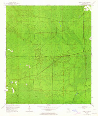
1954 Map of Cross City SW
USGS Topo · Published 1964About this map
California Swamp dominates this coastal lowland in Dixie County, reflecting a mid-century landscape defined by wet timberland and timber extraction infrastructure. An Old Railroad Grade cuts across the terrain, indicating the historical reach of industrial logging in an area where solid ground is at a premium. Small rises in the topography provide enough dry earth for isolated human footprints, such as Sandhill Cem and the Horseshoe Lookout Tower. These landmarks served as vital points of reference for local residents and forest managers navigating the dense thickets and marshes. Along the southern reaches, the winding path of Fishbone Creek feeds into Station Lake, while Davis Island stands as a distinct landform within the surrounding wetland system.
Find a feature on this map
9 named features on this map. Tap any name to fly to it.
Don’t see what you’re looking for? This feature index may not catch every label — zoom into the map to look around manually.
Map Details
Editions of this 1954 Cross City SW Map
4 editions found
Other maps of this area

1954 · Cross City West
USGS Topo · 1:24,000

1954 · Eugene
USGS Topo · 1:24,000

1954 · Cross City East
USGS Topo · 1:24,000

1954 · Jena
USGS Topo · 1:24,000

1954 · Steinhatchee SE
USGS Topo · 1:24,000

1954 · Cross City SW
USGS Topo · 1:24,000

1954 · Horseshoe Beach
USGS Topo · 1:24,000

1954 · Vista
USGS Topo · 1:24,000

1954 · Gainesville
USGS Topo · 1:250,000

1955 · Shired Island
USGS Topo · 1:24,000