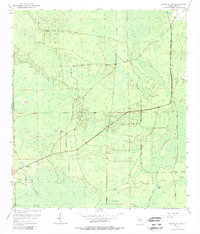
1954 Map of Cross City SW
USGS Topo · Published 1988About this map
California Swamp dominates this coastal lowland landscape in Dixie County, reflecting the watery, low-lying geography of the Gulf Hammock region during the mid-1950s. The terrain is characterized by an intricate network of wetlands and small water bodies such as Station Lake and Fishbone Creek, with slightly higher elevations indicated by Davis Island. This environment necessitated specialized infrastructure for timber and transport, evidenced by the prominent Old Railroad Grade cutting through the hammocks.
Find a feature on this map
9 named features on this map. Tap any name to fly to it.
Don’t see what you’re looking for? This feature index may not catch every label — zoom into the map to look around manually.
Map Details
Editions of this 1954 Cross City SW Map
4 editions found
Other maps of this area

1954 · Cross City West
USGS Topo · 1:24,000

1954 · Eugene
USGS Topo · 1:24,000

1954 · Cross City East
USGS Topo · 1:24,000

1954 · Jena
USGS Topo · 1:24,000

1954 · Steinhatchee SE
USGS Topo · 1:24,000

1954 · Cross City SW
USGS Topo · 1:24,000

1954 · Horseshoe Beach
USGS Topo · 1:24,000

1954 · Vista
USGS Topo · 1:24,000

1954 · Gainesville
USGS Topo · 1:250,000

1955 · Shired Island
USGS Topo · 1:24,000