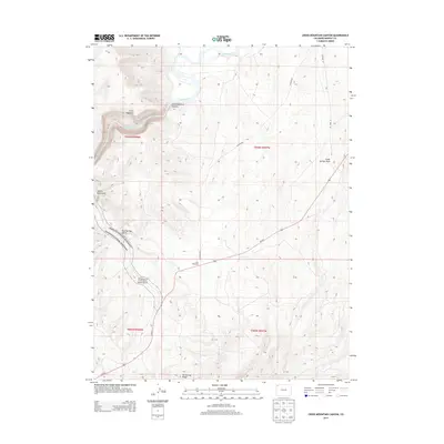
2013 Map of Cross Mountain Canyon
USGS Topo · Published 2013About this map
The Yampa River carves a deep path through the northwestern Colorado landscape, most notably through the steep-walled Cross Mountain Canyon at the western edge of Cross Mountain. This 2013 survey illustrates the intersection of public lands and natural drainage systems, with a significant portion of the southwestern quadrant designated as part of Dinosaur National Monument. The terrain is defined by complex erosional features including Twelve Mile Gulch, Mud Springs Gulch, and Cedar Springs Draw, which drain toward the river basin.
Find a feature on this map
15 named features on this map. Tap any name to fly to it.
Don’t see what you’re looking for? This feature index may not catch every label — zoom into the map to look around manually.
Map Details
Editions of this 2013 Cross Mountain Canyon Map
This is the sole edition of this map. No revisions or reprints were ever made.
Other maps of this area

1907 · White River
USGS Topo · 1:125,000

1910 · White River
USGS Topo · 1:125,000

1954 · Vernal
USGS Topo · 1:250,000

1958 · Vernal
USGS Topo · 1:250,000

1958 · Maybell
USGS Topo · 1:62,500

1958 · Citadel Plateau
USGS Topo · 1:62,500

1960 · Vernal
USGS Topo · 1:250,000

1960 · Elk Springs
USGS Topo · 1:62,500

1960 · Lone Mountain
USGS Topo · 1:62,500
1979 · Rangely
USGS Topo · 1:100,000