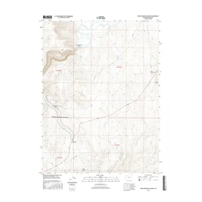
2016 Map of Cross Mountain Canyon
USGS Topo · Published 2016About this map
The Yampa River carves directly through the heart of the high desert landscape, defining the dramatic geology of Cross Mountain Canyon. This 2016 survey illustrates a largely uninhabited portion of Moffat County, where the topography is dictated by massive landforms like Cross Mtn and the extended Elk Springs Ridge to the south. The northern edge of the Dinosaur National Monument boundary cuts across the terrain, accessed by the Dinosaur Park Svc Rd. The map's detail focuses on the complex drainage network of the region, including named features such as Twelve Mile Gulch, Mud Springs Gulch, and Cedar Springs Draw. While permanent settlements are absent, the map traces the essential infrastructure of the modern West, from the Power Line Rd to remote county routes like Co RD 85.
Find a feature on this map
18 named features on this map. Tap any name to fly to it.
Don’t see what you’re looking for? This feature index may not catch every label — zoom into the map to look around manually.
Map Details
Editions of this 2016 Cross Mountain Canyon Map
This is the sole edition of this map. No revisions or reprints were ever made.
Other maps of this area

1907 · White River
USGS Topo · 1:125,000

1910 · White River
USGS Topo · 1:125,000

1954 · Vernal
USGS Topo · 1:250,000

1958 · Vernal
USGS Topo · 1:250,000

1958 · Maybell
USGS Topo · 1:62,500

1958 · Citadel Plateau
USGS Topo · 1:62,500

1960 · Vernal
USGS Topo · 1:250,000

1960 · Elk Springs
USGS Topo · 1:62,500

1960 · Lone Mountain
USGS Topo · 1:62,500
1979 · Rangely
USGS Topo · 1:100,000