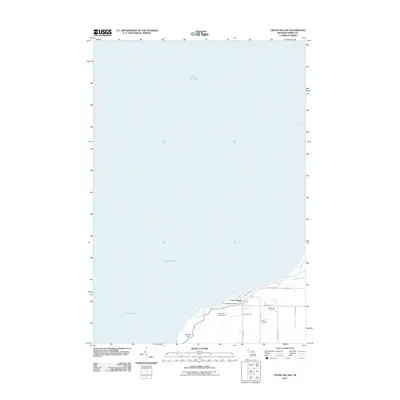
2011 Map of Cross Village
USGS Topo · Published 2011About this map
Cross Village occupies a prominent position on the shoreline of Lake Michigan in this 2011 survey, centered around a compact network of roads including Lower Shore Dr and W Levering Rd. The map highlights the local significance of the Cross Village Post Office and the Lakeshore Campground, reflecting the area's role as a coastal community and seasonal destination. Further inland, McCort Hill provides a distinct topographic rise overlooking the waters of Sturgeon Bay. Genealogy and local history researchers will find the placement of Holy Cross Cemetery and the Indian Cemetery particularly valuable for tracing lineage and settlement patterns within Emmet County. The presence of Wycamp Creek and a network of secondary roads like Arbutus Rd and Lookout Rd illustrate the rural, residential expansion away from the village center.
Find a feature on this map
18 named features on this map. Tap any name to fly to it.
Don’t see what you’re looking for? This feature index may not catch every label — zoom into the map to look around manually.
Map Details
Editions of this 2011 Cross Village Map
This is the sole edition of this map. No revisions or reprints were ever made.
Other maps of this area

1955 · Cheboygan
USGS Topo · 1:250,000

1958 · Cheboygan
USGS Topo · 1:250,000

1958 · Cross Village
USGS Topo · 1:62,500

1958 · Pellston
USGS Topo · 1:62,500

1964 · Big Stone Bay
USGS Topo · 1:24,000
1982 · Bliss
USGS Topo · 1:25,000
1982 · Good Hart
USGS Topo · 1:25,000
1982 · Waugoshance Island
USGS Topo · 1:25,000
1982 · Larks Lake
USGS Topo · 1:25,000
1982 · Cross Village
USGS Topo · 1:25,000