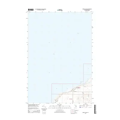
2014 Map of Cross Village
USGS Topo · Published 2014About this map
Cross Village occupies the high bluffs overlooking the northeastern reaches of Lake Michigan and Sturgeon Bay on this Michigan coastal survey. The settlement is defined by its dramatic position above the shoreline, where McCort Hill rises sharply from the water's edge. A network of local roads including N Lake Shore Dr and N State Rd connects the village to the surrounding landscape of Emmet County. The presence of Holy Cross Cem at the southern edge of the settled area and Cemetery Rd highlights the long-standing community footprint in this region. To the east, the terrain levels out slightly as Wycamp Cr flows toward the lake, marking a transition from the elevated village site to the more interior township lands.
Find a feature on this map
26 named features on this map. Tap any name to fly to it.
Don’t see what you’re looking for? This feature index may not catch every label — zoom into the map to look around manually.
Map Details
Editions of this 2014 Cross Village Map
This is the sole edition of this map. No revisions or reprints were ever made.
Other maps of this area

1955 · Cheboygan
USGS Topo · 1:250,000

1958 · Cheboygan
USGS Topo · 1:250,000

1958 · Cross Village
USGS Topo · 1:62,500

1958 · Pellston
USGS Topo · 1:62,500

1964 · Big Stone Bay
USGS Topo · 1:24,000
1982 · Bliss
USGS Topo · 1:25,000
1982 · Good Hart
USGS Topo · 1:25,000
1982 · Waugoshance Island
USGS Topo · 1:25,000
1982 · Larks Lake
USGS Topo · 1:25,000
1982 · Cross Village
USGS Topo · 1:25,000