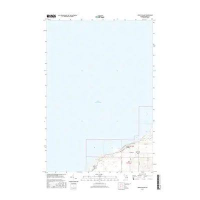
2017 Map of Cross Village
USGS Topo · Published 2017About this map
Cross Village sits prominently along the elevated bluffs of Lake Michigan in this Northern Michigan landscape. The settlement is defined by its coastal orientation, with N Lake Shore Dr and Lower Shore Dr following the contours of the shoreline. The map reveals a dense concentration of local history markers, specifically the three distinct burial grounds: Cross Village Cem, Holy Cross Cem, and Indian Cem. These sites, along with the nearby McCort Hill, suggest a deeply rooted community structure that has persisted along the lake's edge. To the south, the topography transitions toward the drainage of Wycamp Cr, while the grid-based road network including W Levering Rd and N State Rd provides the primary connections inland through the forested terrain of the northern Lower Peninsula.
Find a feature on this map
28 named features on this map. Tap any name to fly to it.
Don’t see what you’re looking for? This feature index may not catch every label — zoom into the map to look around manually.
Map Details
Editions of this 2017 Cross Village Map
This is the sole edition of this map. No revisions or reprints were ever made.
Other maps of this area

1955 · Cheboygan
USGS Topo · 1:250,000

1958 · Cheboygan
USGS Topo · 1:250,000

1958 · Cross Village
USGS Topo · 1:62,500

1958 · Pellston
USGS Topo · 1:62,500

1964 · Big Stone Bay
USGS Topo · 1:24,000
1982 · Bliss
USGS Topo · 1:25,000
1982 · Good Hart
USGS Topo · 1:25,000
1982 · Waugoshance Island
USGS Topo · 1:25,000
1982 · Larks Lake
USGS Topo · 1:25,000
1982 · Cross Village
USGS Topo · 1:25,000