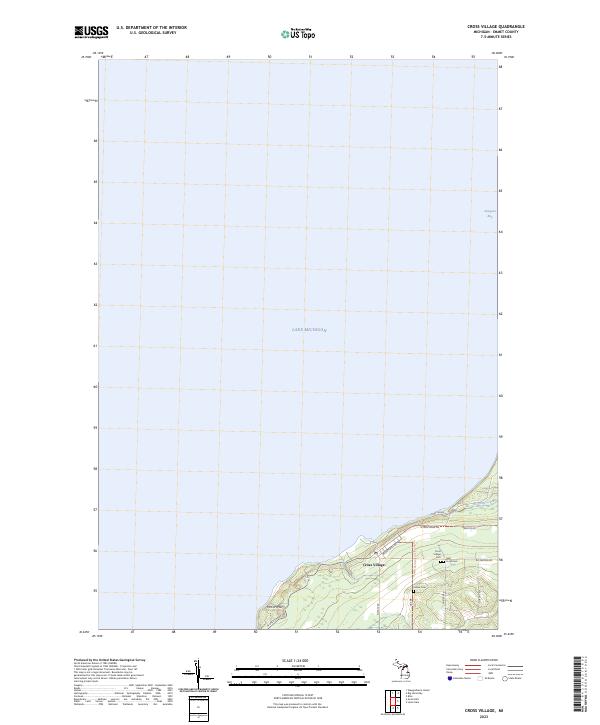
2023 Map of Cross Village
USGS Topo · Published 2023About this map
Cross Village sits along the high bluffs of Emmet County, overlooking the expansive waters of Lake Michigan and the northern reaches of Sturgeon Bay. This coastal landscape is defined by its significant historical burial grounds, including the Cross Village Cem, Holy Cross Cem, and the Indian Cem, reflecting the deep cultural layers of this lakeside settlement. The terrain rises from the shore toward McCort Hill, while the local road network, including Wadsworth Rd and N Lake Shore Dr, traces the natural contours of the shoreline and the surrounding forest lands. To the northeast, the waters of Wycamp Creek flow toward the bay, marking a transition from the village center into more secluded coastal environments. The mapping of these townships, t38n r6w and t37n r6w, captures the persistent layout of one of Michigan's oldest continuously inhabited sites in the modern era.
Find a feature on this map
19 named features on this map. Tap any name to fly to it.
Don’t see what you’re looking for? This feature index may not catch every label — zoom into the map to look around manually.
Map Details
Editions of this 2023 Cross Village Map
This is the sole edition of this map. No revisions or reprints were ever made.
Other maps of this area

1955 · Cheboygan
USGS Topo · 1:250,000

1958 · Cheboygan
USGS Topo · 1:250,000

1958 · Cross Village
USGS Topo · 1:62,500

1958 · Pellston
USGS Topo · 1:62,500

1964 · Big Stone Bay
USGS Topo · 1:24,000
1982 · Bliss
USGS Topo · 1:25,000
1982 · Good Hart
USGS Topo · 1:25,000
1982 · Waugoshance Island
USGS Topo · 1:25,000
1982 · Larks Lake
USGS Topo · 1:25,000
1982 · Cross Village
USGS Topo · 1:25,000