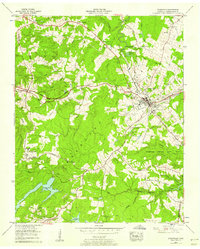
1956 Map of Crossville
USGS Topo · Published 1958About this map
The Tennessee Valley Divide snakes through the heart of this mid-century survey, separating the waters of the Obed River from the Tennessee River drainage. At the center of the plateau, the city of Crossville serves as a regional hub, where the Tennessee Central Ry intersects with the Alvin C. York Highway and Broadway. The map documents a period of infrastructure expansion, showing the William Howard Highway (Under Construction) cutting through the landscape toward the Crossville Municipal Airport.
Find a feature on this map
70 named features on this map. Tap any name to fly to it.
Don’t see what you’re looking for? This feature index may not catch every label — zoom into the map to look around manually.
Map Details
Editions of this 1956 Crossville Map
3 editions found
Other maps of this area

1887 · Kingston
USGS Topo · 1:125,000

1891 · Kingston
USGS Topo · 1:125,000

1892 · Pikeville
USGS Topo · 1:125,000

1893 · Kingston
USGS Topo · 1:125,000

1895 · Wartburg
USGS Topo · 1:125,000

1895 · Pikeville
USGS Topo · 1:125,000

1896 · Wartburg
USGS Topo · 1:125,000

1897 · Standingstone
USGS Topo · 1:125,000

1898 · Standingstone
USGS Topo · 1:125,000

1912 · Crossville
USGS Topo · 1:62,500