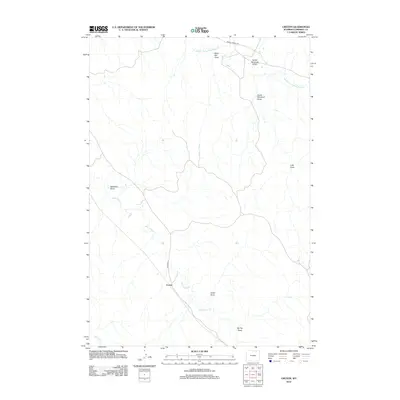
2012 Map of Croton
USGS Topo · Published 2012About this map
Croton serves as the central point of reference in this Campbell County landscape, situated where Echeta Rd crosses the upper reaches of Wild Horse Cr. The drainage patterns here reveal a complex system of seasonal watercourses and topographic depressions, with Middle Prong Wild Horse Cr carving through the northern section. The map documents a sparsely populated ranching environment defined by its numerous named draws, such as Deadman Draw and Black Bill Draw, which suggest a long history of local nomenclature tied to the land's rugged character. Transportation in the early 21st century remains focused on established routes like Middle Prong Rd, providing access to the outlying draws including North Windmill Draw and South Windmill Draw.
Find a feature on this map
13 named features on this map. Tap any name to fly to it.
Don’t see what you’re looking for? This feature index may not catch every label — zoom into the map to look around manually.
Map Details
Editions of this 2012 Croton Map
This is the sole edition of this map. No revisions or reprints were ever made.
Other maps of this area

1954 · Gillette
USGS Topo · 1:250,000

1955 · Sheridan
USGS Topo · 1:250,000

1955 · Gillette
USGS Topo · 1:250,000

1958 · Gillette
USGS Topo · 1:250,000

1958 · Sheridan
USGS Topo · 1:250,000

1962 · Gillette
USGS Topo · 1:250,000

1962 · Sheridan
USGS Topo · 1:250,000

1971 · Larey Draw
USGS Topo · 1:24,000
1971 · Spotted Horse
USGS Topo · 1:24,000
1971 · Arvada NE
USGS Topo · 1:24,000