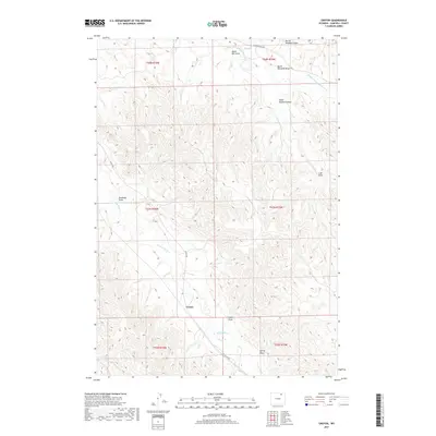
2017 Map of Croton
USGS Topo · Published 2017About this map
Croton is the primary settlement shown in this high plains landscape of Campbell County, characterized by a complex network of ephemeral drainage systems. The terrain is defined by numerous named draws, including Deadman Draw and Lake Draw, which feed into larger watercourses such as Wild Horse Cr and Middle Prong Wild Horse Cr. These geographical features speak to the hydrologic challenges and ranching history of the region, where water management is central to the land's utility. Transport through this area is facilitated by Echeta Rd and Middle Prong Rd, which wind through the township and range divisions. The map provides a detailed view of the local topography, from Black Bill Draw in the north to Deer Cr in the southwest, showing the intricate landform patterns that have influenced settlement and movement in this part of Wyoming.
Find a feature on this map
19 named features on this map. Tap any name to fly to it.
Don’t see what you’re looking for? This feature index may not catch every label — zoom into the map to look around manually.
Map Details
Editions of this 2017 Croton Map
This is the sole edition of this map. No revisions or reprints were ever made.
Other maps of this area

1954 · Gillette
USGS Topo · 1:250,000

1955 · Sheridan
USGS Topo · 1:250,000

1955 · Gillette
USGS Topo · 1:250,000

1958 · Gillette
USGS Topo · 1:250,000

1958 · Sheridan
USGS Topo · 1:250,000

1962 · Gillette
USGS Topo · 1:250,000

1962 · Sheridan
USGS Topo · 1:250,000

1971 · Larey Draw
USGS Topo · 1:24,000
1971 · Spotted Horse
USGS Topo · 1:24,000
1971 · Arvada NE
USGS Topo · 1:24,000