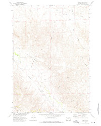
1972 Map of Croton
USGS Topo · Published 1975About this map
Croton sits at the convergence of the Burlington Northern railroad and Echeta Road in this 1970s study of the Campbell County landscape. The topography is defined by an intricate network of drainage channels, including Wild Horse Creek, Black Bill Draw, and Deadman Draw, which snake through the varied elevation. This era of the Missouri River Basin development is characterized here by a reliance on water resources and energy exploration, evidenced by numerous labeled Wells and Drill Holes scattered across the township lines. The transition from established infrastructure like the railroad to more ephemeral routes, such as the Jeep Trail in the south, highlights the region's ranching and industrial utility. Named features like North Windmill Draw and South Windmill Draw suggest a history of livestock management and water access in this semi-arid Wyoming environment.
Find a feature on this map
16 named features on this map. Tap any name to fly to it.
Don’t see what you’re looking for? This feature index may not catch every label — zoom into the map to look around manually.
Map Details
Editions of this 1972 Croton Map
This is the sole edition of this map. No revisions or reprints were ever made.
Other maps of this area

1954 · Gillette
USGS Topo · 1:250,000

1955 · Sheridan
USGS Topo · 1:250,000

1955 · Gillette
USGS Topo · 1:250,000

1958 · Gillette
USGS Topo · 1:250,000

1958 · Sheridan
USGS Topo · 1:250,000

1962 · Gillette
USGS Topo · 1:250,000

1962 · Sheridan
USGS Topo · 1:250,000

1971 · Larey Draw
USGS Topo · 1:24,000
1971 · Spotted Horse
USGS Topo · 1:24,000
1971 · Arvada NE
USGS Topo · 1:24,000