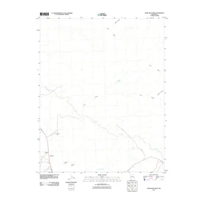
2010 Map of Crow Mesa West
USGS Topo · Published 2010About this map
Nageezi sits at the southwestern edge of this high desert landscape, serving as a primary point of settlement along the local road network. The community is anchored by the Nageezi Post Office, with water management defined by a series of local structures including Nageezi Dam, Cricket Dam, and LaCopita Dam. These features illustrate the necessity of controlling seasonal runoff in an arid environment where drainage is dictated by the broad Blanco Wash and the winding Kimbeto Wash.
Find a feature on this map
13 named features on this map. Tap any name to fly to it.
Don’t see what you’re looking for? This feature index may not catch every label — zoom into the map to look around manually.
Map Details
Editions of this 2010 Crow Mesa West Map
This is the sole edition of this map. No revisions or reprints were ever made.
Other maps of this area

1889 · Largo
USGS Topo · 1:250,000

1895 · Largo
USGS Topo · 1:250,000

1954 · Aztec
USGS Topo · 1:250,000

1958 · Aztec
USGS Topo · 1:250,000

1959 · Nageezi
USGS Topo · 1:62,500

1962 · Aztec
USGS Topo · 1:250,000

1965 · Aztec
USGS Topo · 1:250,000

1966 · Lybrook NW
USGS Topo · 1:24,000
1966 · Lybrook
USGS Topo · 1:24,000
1966 · Blanco Trading Post
USGS Topo · 1:24,000