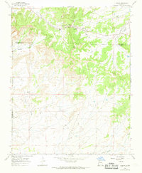
1966 Map of Lybrook
USGS Topo · Published 1969About this map
Lybrook sits at the northern edge of this high-desert landscape in the mid-1960s, serving as a hub for the surrounding ranching and resource extraction economy. The map documents a specific period of development where traditional Navajo trading culture met the expanding oil and gas industry, evidenced by the proximity of the Lybrook Navajo Mission and Escrito Trading Post to numerous Oil Wells and a complex network of pipelines. The terrain is defined by dramatic erosion, where the Sisnathyel Mesa overlooks a series of dry drainages including Blanco Wash and Alamito Arroyo. Geodetic markers and a Radio Tower near the town center underscore the area's role as a navigational and communication point within the San Juan Basin. Cultural markers like Tsosie Hutton and Maury Trading Post provide valuable points of reference for those researching the mid-century social geography of this region.
Find a feature on this map
27 named features on this map. Tap any name to fly to it.
Don’t see what you’re looking for? This feature index may not catch every label — zoom into the map to look around manually.
Map Details
Editions of this 1966 Lybrook Map
2 editions found
Other maps of this area

1889 · Largo
USGS Topo · 1:250,000

1895 · Largo
USGS Topo · 1:250,000

1954 · Aztec
USGS Topo · 1:250,000

1958 · Aztec
USGS Topo · 1:250,000

1959 · Nageezi
USGS Topo · 1:62,500

1962 · Aztec
USGS Topo · 1:250,000

1963 · Tayfoya Canyon
USGS Topo · 1:24,000

1965 · Aztec
USGS Topo · 1:250,000

1966 · Lybrook NW
USGS Topo · 1:24,000
1966 · Mule Dam
USGS Topo · 1:24,000