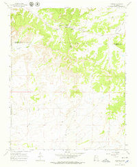
1966 Map of Lybrook
USGS Topo · Published 1979About this map
Lybrook and the surrounding desert plateau sit at a triple-county juncture in northern New Mexico, defined by a sparse but active network of energy extraction and remote outposts during the mid-1960s. The settlement at Lybrook Navajo Mission serves as a focal point in a landscape marked by the Many Trading Post and Escrito Trading Post, reflecting the vital role of these centers in the regional economy. The terrain is deeply incised by drainages such as Blanco Wash and Escavada Wash, which wind through canyons like Hutton Canyon and Betonnie Tsosie Canyon. This period saw significant industrial activity, evidenced by numerous Oil Wells and a prominent Pipeline cutting across the high ground of Sisnathy Mesa. A remote Landing Strip and a Radio Tower highlight the importance of communication and aerial access in this isolated stretch of the San Juan Basin.
Find a feature on this map
24 named features on this map. Tap any name to fly to it.
Don’t see what you’re looking for? This feature index may not catch every label — zoom into the map to look around manually.
Map Details
Editions of this 1966 Lybrook Map
2 editions found
Other maps of this area

1889 · Largo
USGS Topo · 1:250,000

1895 · Largo
USGS Topo · 1:250,000

1954 · Aztec
USGS Topo · 1:250,000

1958 · Aztec
USGS Topo · 1:250,000

1959 · Nageezi
USGS Topo · 1:62,500

1962 · Aztec
USGS Topo · 1:250,000

1963 · Tayfoya Canyon
USGS Topo · 1:24,000

1965 · Aztec
USGS Topo · 1:250,000

1966 · Lybrook NW
USGS Topo · 1:24,000
1966 · Mule Dam
USGS Topo · 1:24,000