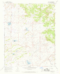
1966 Map of Mule Dam
USGS Topo · Published 1969About this map
Sisnathyel Mesa dominates the northern landscape of this Sandoval County terrain, where the Jicarilla Apache Indian Reservation Boundary marks a significant division in the land. The mapping reveals a complex network of water management features essential for this arid environment, including Mule Dam, Chimney Dam, and the Big Island CCC Tank, the latter suggesting New Deal era infrastructure. Livestock and land use are further evidenced by isolated landmarks such as Dennison Well, Herrera Well, and White Point Well. Running through the southeastern portion of the sheet, the Continental Divide serves as the primary hydrological spine, influencing the drainage of the Cañada Corrales and Encino Wash. The presence of several Drill Holes points to subsurface exploration during the mid-1960s, a period when the region was primarily navigated by a network of Jeep Trails.
Find a feature on this map
20 named features on this map. Tap any name to fly to it.
Don’t see what you’re looking for? This feature index may not catch every label — zoom into the map to look around manually.
Map Details
Editions of this 1966 Mule Dam Map
2 editions found
Other maps of this area

1883 · Mt. Taylor
USGS Topo · 1:250,000

1886 · Mt. Taylor
USGS Topo · 1:250,000

1889 · Largo
USGS Topo · 1:250,000

1892 · Mt. Taylor
USGS Topo · 1:250,000

1895 · Largo
USGS Topo · 1:250,000

1899 · Mt. Taylor
USGS Topo · 1:250,000

1954 · Aztec
USGS Topo · 1:250,000

1958 · Aztec
USGS Topo · 1:250,000

1958 · Albuquerque
USGS Topo · 1:250,000

1960 · Pueblo Alto Trading Post
USGS Topo · 1:24,000