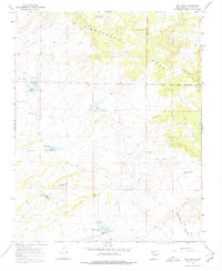
1966 Map of Mule Dam
USGS Topo · Published 1978About this map
The high plateau of Sisnathyel Mesa dominates this 1960s landscape, illustrating the intricate water-management systems required for ranching and survival in Sandoval County. The survey identifies a network of engineered livestock tanks and catchments, including Mule Dam, Chimney Dam, and the Big Island CCC Tank, the latter reflecting earlier federal conservation work in the region. The Jicarilla Apache Indian Reservation Boundary runs along the eastern portion of the sheet, marking a significant jurisdictional division across the high desert terrain.
Find a feature on this map
20 named features on this map. Tap any name to fly to it.
Don’t see what you’re looking for? This feature index may not catch every label — zoom into the map to look around manually.
Map Details
Editions of this 1966 Mule Dam Map
2 editions found
Other maps of this area

1883 · Mt. Taylor
USGS Topo · 1:250,000

1886 · Mt. Taylor
USGS Topo · 1:250,000

1889 · Largo
USGS Topo · 1:250,000

1892 · Mt. Taylor
USGS Topo · 1:250,000

1895 · Largo
USGS Topo · 1:250,000

1899 · Mt. Taylor
USGS Topo · 1:250,000

1954 · Aztec
USGS Topo · 1:250,000

1958 · Aztec
USGS Topo · 1:250,000

1958 · Albuquerque
USGS Topo · 1:250,000

1960 · Pueblo Alto Trading Post
USGS Topo · 1:24,000