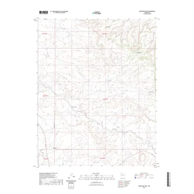
2023 Map of Crow Mesa West
USGS Topo · Published 2023About this map
Nageezi sits along the southern edge of this high-desert plateau, serving as a focal point for a landscape defined by significant drainage systems and mesas. The territory is dominated by the broad course of the Blanco Wash, which cuts diagonally across the center of the sheet, and the Kimbeto Wash to the south. These seasonal watercourses have carved out intricate networks including Crow Canyon and Selph Canyon, leading up to the prominent landform of Crow Mesa. A network of rural routes, including Indian Svc Rte 459 and Co RD 7775, provides access through this arid environment. The map provides a detailed view of the high-elevation terrain and isolated water features like Crow Lake, illustrating the sparse settlement patterns and natural topography of this part of San Juan County.
Find a feature on this map
23 named features on this map. Tap any name to fly to it.
Don’t see what you’re looking for? This feature index may not catch every label — zoom into the map to look around manually.
Map Details
Editions of this 2023 Crow Mesa West Map
This is the sole edition of this map. No revisions or reprints were ever made.
Other maps of this area

1889 · Largo
USGS Topo · 1:250,000

1895 · Largo
USGS Topo · 1:250,000

1954 · Aztec
USGS Topo · 1:250,000

1958 · Aztec
USGS Topo · 1:250,000

1959 · Nageezi
USGS Topo · 1:62,500

1962 · Aztec
USGS Topo · 1:250,000

1965 · Aztec
USGS Topo · 1:250,000

1966 · Lybrook NW
USGS Topo · 1:24,000
1966 · Lybrook
USGS Topo · 1:24,000
1966 · Blanco Trading Post
USGS Topo · 1:24,000