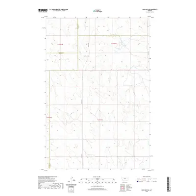
2020 Map of Crow Rock SE
USGS Topo · Published 2020About this map
Chalk Butte serves as a prominent landmark in this corner of Eastern Montana, where the jurisdictional boundaries of Garfield, Prairie, Rosebud, and Custer counties converge. The landscape is defined by its drainage network, with Wolf Cr and E Wall Cr flowing through the western sections while Crow Rock Cr and Grimes Cr carve through the eastern reaches. This modern survey illustrates the sparse, ranch-oriented infrastructure of the region, anchored by the long corridor of Crow Rock Rd. The map provides a detailed view of the section lines and township divisions, including t13n r45e, essential for land ownership research and tracing the movement of agricultural families across these high plains. Secondary routes like Deadman Rd and Rd 112 connect the open range, marking the enduring paths through this rural landscape.
Find a feature on this map
16 named features on this map. Tap any name to fly to it.
Don’t see what you’re looking for? This feature index may not catch every label — zoom into the map to look around manually.
Map Details
Editions of this 2020 Crow Rock SE Map
This is the sole edition of this map. No revisions or reprints were ever made.
Other maps of this area

1953 · Miles City
USGS Topo · 1:250,000

1954 · Forsyth
USGS Topo · 1:250,000

1957 · Miles City
USGS Topo · 1:250,000

1957 · Forsyth
USGS Topo · 1:250,000

1958 · Miles City
USGS Topo · 1:250,000

1958 · Forsyth
USGS Topo · 1:250,000

1965 · Rock Springs School
USGS Topo · 1:24,000

1965 · Little Chalk Butte
USGS Topo · 1:24,000

1965 · Twin Buttes School
USGS Topo · 1:24,000
1965 · Combs Ranch
USGS Topo · 1:24,000