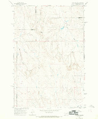
1965 Map of Crow Rock SE
USGS Topo · Published 1969About this map
Chalk Butte stands as a prominent topographical landmark in this 1965 field-checked survey of the Montana interior. The landscape is defined by its complex drainage network, where Wolf Creek and Crow Rock Creek carve through the terrain, meeting near the intersection of several county lines. This area represents a crossroads of local administration, showing the convergence of Garfield, Rosebud, Custer, and Prairie counties. Human presence in this open range is sparse but distinct, marked by the Fairview Sch and several remote wells. Evidence of resource exploration appears in the form of a Prospect located near the headwaters of the East Fork Creek, while Grimes Creek drains the southeastern portion of the quadrangle. The map captures a moment in the mid-1960s when these rural schoolhouses and small-scale mining interests still anchored the local geography.
Find a feature on this map
13 named features on this map. Tap any name to fly to it.
Don’t see what you’re looking for? This feature index may not catch every label — zoom into the map to look around manually.
Map Details
Editions of this 1965 Crow Rock SE Map
This is the sole edition of this map. No revisions or reprints were ever made.
Other maps of this area

1953 · Miles City
USGS Topo · 1:250,000

1954 · Forsyth
USGS Topo · 1:250,000

1957 · Miles City
USGS Topo · 1:250,000

1957 · Forsyth
USGS Topo · 1:250,000

1958 · Miles City
USGS Topo · 1:250,000

1958 · Forsyth
USGS Topo · 1:250,000

1965 · Rock Springs School
USGS Topo · 1:24,000

1965 · Little Chalk Butte
USGS Topo · 1:24,000

1965 · Twin Buttes School
USGS Topo · 1:24,000
1965 · Combs Ranch
USGS Topo · 1:24,000