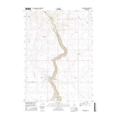
2017 Map of Crowbar Gulch
USGS Topo · Published 2017About this map
The Bruneau River carves a deep, winding path through Owyhee County, defining the dramatic topography of Bruneau Canyon. This high desert landscape is characterized by expansive plateaus like the Bruneau Desert and distinctive volcanic landmarks such as Twin Buttes in the northwest. Local ranching and travel history are reflected in the network of remote tracks, including Broken Wagon Flat Rd and Blackstone Grasmere Rd, which navigate the arid terrain. The presence of named water sources like Miller Water and Miller Water-Table in an otherwise dry environment highlights the critical importance of reliable springs and subsurface flow for survival and livestock in this portion of the Idaho backcountry. Watercourses such as Browns Cr and the namesake Crowbar Gulch further illustrate the drainage patterns feeding into the central river system.
Find a feature on this map
17 named features on this map. Tap any name to fly to it.
Don’t see what you’re looking for? This feature index may not catch every label — zoom into the map to look around manually.
Map Details
Editions of this 2017 Crowbar Gulch Map
This is the sole edition of this map. No revisions or reprints were ever made.
Other maps of this area

1947 · Bruneau
USGS Topo · 1:62,500

1947 · Sugar Valley
USGS Topo · 1:24,000

1947 · Hot Spring
USGS Topo · 1:24,000

1948 · Sugar Valley
USGS Topo · 1:24,000

1948 · Indian Cove
USGS Topo · 1:62,500

1948 · Pence Butte
USGS Topo · 1:24,000
1949 · Pence Butte
USGS Topo · 1:24,000
1949 · Hot Spring
USGS Topo · 1:24,000

1955 · Twin Falls
USGS Topo · 1:250,000

1956 · Big Hill
USGS Topo · 1:62,500