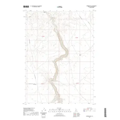
2020 Map of Crowbar Gulch
USGS Topo · Published 2020About this map
The Bruneau River carves a deep, sinuous path through Owyhee County, defining the stark geography of the Bruneau Canyon. This landscape is a complex network of arid terrain and high-desert drainage patterns, where the deep incisions of Crowbar Gulch and the Big Draw move toward the central river corridor. To the west, Twin Buttes provides a distinct topographic landmark amidst a wide expanse of open country. Long-established backroads, including Blackstone Grasmere Rd and Broken Wagon Flat Rd, reveal the remote infrastructure of the Bruneau Desert. The presence of Miller Water Table and Miller Water suggests the critical importance of specific water sources in this high-plateau environment, essential for the ranching and resource management history of the Idaho panhandle's southern reaches.
Find a feature on this map
16 named features on this map. Tap any name to fly to it.
Don’t see what you’re looking for? This feature index may not catch every label — zoom into the map to look around manually.
Map Details
Editions of this 2020 Crowbar Gulch Map
This is the sole edition of this map. No revisions or reprints were ever made.
Other maps of this area

1947 · Bruneau
USGS Topo · 1:62,500

1947 · Sugar Valley
USGS Topo · 1:24,000

1947 · Hot Spring
USGS Topo · 1:24,000

1948 · Sugar Valley
USGS Topo · 1:24,000

1948 · Indian Cove
USGS Topo · 1:62,500

1948 · Pence Butte
USGS Topo · 1:24,000
1949 · Pence Butte
USGS Topo · 1:24,000
1949 · Hot Spring
USGS Topo · 1:24,000

1955 · Twin Falls
USGS Topo · 1:250,000

1956 · Big Hill
USGS Topo · 1:62,500