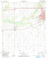
1983 Map of Crowley West
USGS Topo · Published 1991About this map
Crowley anchors the eastern edge of this landscape, where the urban grid meets a vast network of irrigation flumes and elevated canals essential for rice cultivation. The intricate water management system follows the natural curves of Bayou Plaquemine Brule and Bayou Blanc, illustrating the region's agricultural engineering. Along the Southern Pacific and Missouri Pacific railroad corridors, smaller settlements like Estherwood and Midland serve as hubs for the surrounding prairie. Beyond the residential streets of Crowley, which include landmarks like Ross Sch and Southwest Louisiana Voc-Tech Sch, the map reveals a heavy industrial presence of gas wells and pipelines. The transition from the town's parks, such as Hoffpauir Park and Martin Luther King Park, to the rural expanse of Morse highlights the deep connection between Acadia Parish's municipal centers and its working landscape of energy and agriculture.
Find a feature on this map
37 named features on this map. Tap any name to fly to it.
Don’t see what you’re looking for? This feature index may not catch every label — zoom into the map to look around manually.
Map Details
Editions of this 1983 Crowley West Map
2 editions found
Other maps of this area

1935 · Branch
USGS Topo · 1:31,680

1946 · Morse
USGS Topo · 1:31,680

1946 · Mermentau
USGS Topo · 1:31,680

1946 · Kaplan
USGS Topo · 1:31,680

1946 · Rayne
USGS Topo · 1:31,680

1947 · Evangeline
USGS Topo · 1:31,680

1947 · Branch
USGS Topo · 1:31,680

1947 · Iota
USGS Topo · 1:31,680

1949 · Gueydan
USGS Topo · 1:31,680

1949 · Estherwood
USGS Topo · 1:31,680