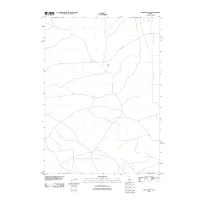
2010 Map of Crows Nest NE
USGS Topo · Published 2010About this map
Deadman Creek winds through this rural landscape of southwestern Idaho, serving as the primary drainage for a region defined by agricultural utility and open range. The topography is dominated by the broad elevation of Indian Ridge, which provides a natural vantage point over the surrounding terrain. This 2010 survey by the U.S. Geological Survey illustrates a sparse settlement pattern where land use is dictated by the availability of water and the orientation of traditional transit routes. Primary access across the high desert floor is maintained by historical road alignments, including the prominent Crows Nest Rd and the Glenns Ferry Castleford Rd. These thoroughfares connect the area to broader regional networks, reflecting the enduring importance of established trails in navigating the Idaho interior.
Find a feature on this map
4 named features on this map. Tap any name to fly to it.
Don’t see what you’re looking for? This feature index may not catch every label — zoom into the map to look around manually.
Map Details
Editions of this 2010 Crows Nest NE Map
This is the sole edition of this map. No revisions or reprints were ever made.
Other maps of this area

1948 · Twentymile Butte
USGS Topo · 1:24,000

1949 · Pasadena Valley
USGS Topo · 1:62,500

1949 · Hagerman
USGS Topo · 1:24,000

1949 · Indian Butte
USGS Topo · 1:24,000

1950 · Hagerman
USGS Topo · 1:24,000
1950 · Indian Butte
USGS Topo · 1:24,000

1955 · Twin Falls
USGS Topo · 1:250,000

1958 · Twin Falls
USGS Topo · 1:250,000

1959 · Buhl
USGS Topo · 1:62,500

1959 · Crows Nest
USGS Topo · 1:62,500