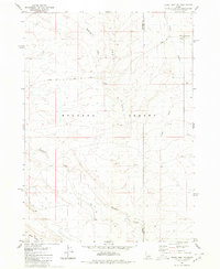
1980 Map of Crows Nest NE
USGS Topo · Published 1980About this map
Bruneau Desert dominates this high-desert landscape on the border of Owyhee and Twin Falls counties as recorded in the mid-1970s. The topography is defined by significant drainages including Rosevear Gulch, Tuana Gulch, and Deadman Creek, which cut through the arid terrain. Human activity in this portion of the Idaho rangelands is primarily indicated by a network of unimproved roads and utility infrastructure, notably Crows Nest Road and the Blue Ridge Trail.
Find a feature on this map
11 named features on this map. Tap any name to fly to it.
Don’t see what you’re looking for? This feature index may not catch every label — zoom into the map to look around manually.
Map Details
Editions of this 1980 Crows Nest NE Map
This is the sole edition of this map. No revisions or reprints were ever made.
Other maps of this area

1948 · Twentymile Butte
USGS Topo · 1:24,000

1949 · Pasadena Valley
USGS Topo · 1:62,500

1949 · Hagerman
USGS Topo · 1:24,000

1949 · Indian Butte
USGS Topo · 1:24,000

1950 · Hagerman
USGS Topo · 1:24,000
1950 · Indian Butte
USGS Topo · 1:24,000

1955 · Twin Falls
USGS Topo · 1:250,000

1958 · Twin Falls
USGS Topo · 1:250,000

1959 · Buhl
USGS Topo · 1:62,500

1959 · Crows Nest
USGS Topo · 1:62,500