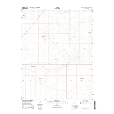
2014 Map of Crows Nest Spring
USGS Topo · Published 2014About this map
The San Rafael Desert landscape of Emery County dominates this 2014 survey, illustrating a geography defined by its arid drainage patterns and scarce water sources. The map focuses on the crucial role of isolated water points, such as Crows Nest Spring and Cottonwood Spring, which have long served as landmarks for travelers and livestock in this expansive arid environment. These features are connected by seasonal drainages like Iron Wash and Cottonwood Wash, which carve through the high desert terrain. Human infrastructure is limited to the corridor of Ut-24, which cuts diagonally across the northwestern sections, providing the primary access through this remote portion of the Utah desert. The detailed contour work highlights the intricate relief of the washes as they break the desert floor, offering insight into the hydrological movement within the t24s r13e and t24s r14e townships.
Find a feature on this map
10 named features on this map. Tap any name to fly to it.
Don’t see what you’re looking for? This feature index may not catch every label — zoom into the map to look around manually.
Map Details
Editions of this 2014 Crows Nest Spring Map
This is the sole edition of this map. No revisions or reprints were ever made.
Other maps of this area

1885 · San Rafael
USGS Topo · 1:250,000

1953 · Tidwell 2 SW
USGS Topo · 1:24,000

1953 · Tidwell 3 NW
USGS Topo · 1:24,000

1953 · Temple Mtn
USGS Topo · 1:62,500

1954 · Stinking Spring Creek 1 SE
USGS Topo · 1:24,000

1954 · Stinking Spring Creek 4 NE
USGS Topo · 1:24,000

1954 · Stinking Spring Creek 4 SE
USGS Topo · 1:24,000

1954 · Tidwell 2 SE
USGS Topo · 1:24,000

1954 · Tidwell Bottoms
USGS Topo · 1:62,500
1954 · The Wickiup
USGS Topo · 1:62,500