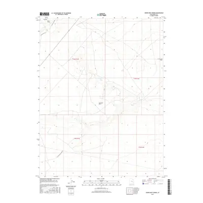
2017 Map of Crows Nest Spring
USGS Topo · Published 2017About this map
The San Rafael Desert dominates this arid landscape of the Colorado Plateau, where water sources are few and far between. Vital desert hydrology is marked by Crows Nest Spring and Cottonwood Spring, serving as essential points in an otherwise parched environment. The terrain is deeply incised by drainage systems such as Iron Wash, which is further detailed by its N Central Iron Wash and S Central Iron Wash branches. Evidence of human activity in the region is sparse, highlighted primarily by the S Cottonwood Exploration road which cuts through the southern reaches of the quadrangle. To the north, the topographic relief increases significantly at Ernie Canyon, providing a sharp contrast to the broader desert floor. This 2017 survey documents the modern state of these remote landmarks within Emery County, mapping the intersection of seasonal washes and isolated springs that have historically dictated travel and survival in the region.
Find a feature on this map
13 named features on this map. Tap any name to fly to it.
Don’t see what you’re looking for? This feature index may not catch every label — zoom into the map to look around manually.
Map Details
Editions of this 2017 Crows Nest Spring Map
This is the sole edition of this map. No revisions or reprints were ever made.
Other maps of this area

1885 · San Rafael
USGS Topo · 1:250,000

1953 · Tidwell 2 SW
USGS Topo · 1:24,000

1953 · Tidwell 3 NW
USGS Topo · 1:24,000

1953 · Temple Mtn
USGS Topo · 1:62,500

1954 · Stinking Spring Creek 1 SE
USGS Topo · 1:24,000

1954 · Stinking Spring Creek 4 NE
USGS Topo · 1:24,000

1954 · Stinking Spring Creek 4 SE
USGS Topo · 1:24,000

1954 · Tidwell 2 SE
USGS Topo · 1:24,000

1954 · Tidwell Bottoms
USGS Topo · 1:62,500
1954 · The Wickiup
USGS Topo · 1:62,500