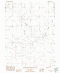
1988 Map of Crows Nest Spring
USGS Topo · Published 1988About this map
San Rafael Desert dominates this 1980s landscape, revealing a remote terrain defined by its scarce water sources and mineral exploration. The presence of a Mine Shaft and Adit near the center of the sheet indicates small-scale mining operations or prospecting efforts tucked into the desert's topography. Water remains the most critical feature for any historic activity here, marked by isolated points like Crows Nest Spring, Cottonwood Spring, and a Flowing Well. These vital oases are connected by rugged 4wd tracks that follow the natural drainage patterns of Cottonwood Wash and Iron Wash. The map documents a moment when traditional land use—centered on stock watering and mining—persisted in this arid portion of Emery County, Utah.
Find a feature on this map
13 named features on this map. Tap any name to fly to it.
Don’t see what you’re looking for? This feature index may not catch every label — zoom into the map to look around manually.
Map Details
Editions of this 1988 Crows Nest Spring Map
This is the sole edition of this map. No revisions or reprints were ever made.
Other maps of this area

1885 · San Rafael
USGS Topo · 1:250,000

1953 · Tidwell 2 SW
USGS Topo · 1:24,000

1953 · Tidwell 3 NW
USGS Topo · 1:24,000

1953 · Temple Mtn
USGS Topo · 1:62,500

1954 · Stinking Spring Creek 1 SE
USGS Topo · 1:24,000

1954 · Stinking Spring Creek 4 NE
USGS Topo · 1:24,000

1954 · Stinking Spring Creek 4 SE
USGS Topo · 1:24,000

1954 · Tidwell 2 SE
USGS Topo · 1:24,000

1954 · Tidwell Bottoms
USGS Topo · 1:62,500
1954 · The Wickiup
USGS Topo · 1:62,500